And it is also pretty strong. From Wunderblog:
India Braces for Extremely Dangerous Tropical Cyclone Phailin
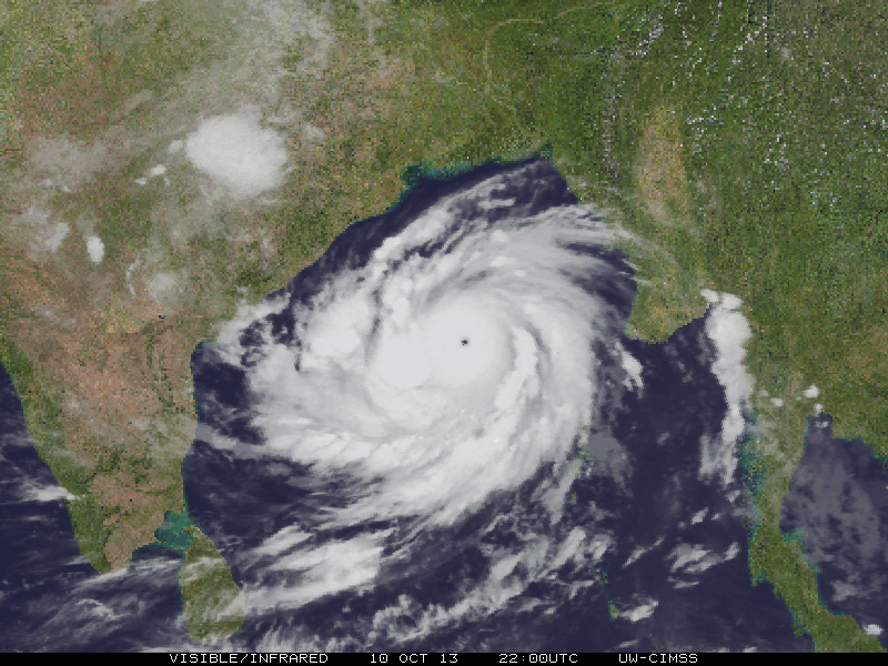
Extremely dangerous Category 5 Tropical Cyclone Phailin is closing in on the northeast coast of India on the Bay of Bengal. Phailin put on a phenomenal burst of rapid intensification on Thursday, going from a tropical storm with 65 mph winds to a top-end Category 4 storm with 155 mph winds in just 24 hours. After reaching peak intensity near 8 pm EDT Thursday, Phailin--whose name means "a sapphire" in Thai--began an eyewall replacement cycle. The eyewall collapsed, and a new, larger-diameter eyewall formed from an outer spiral band. This process typically weakens the top winds of a tropical cyclone by 5 - 15 mph, and satellite estimates of Phailin's central pressure increased from 910 mb to 934 mb during the eyewall replacement cycle, from 04 - 11 UTC Friday. However, satellite images show that Phailin has completed its eyewall replacement cycle and is now re-intensifying, with the cloud tops of the very intense thunderstorms in the eyewall expanding and cooling, as updrafts in the eyewall grow stronger and push the clouds higher into the atmosphere. The latest satellite estimate of Phailin's central pressure had dropped to 920 mb as of 13 UTC (9 am EDT) on Friday, and the Joint Typhoon Warning Center upped Phailin's intensity to a Category 5 storm with 160 mph winds in their 11 am EDT Friday advisory. Radar out of Visakhapanam, India shows that heavy rains from the outer bands of Phailin are already affecting the coast, and these bands were bringing rainfall rates of over an inch per hour, as estimated by microwave data from 10:55 UTC Friday. Phailin is over ocean waters that have warmed since Thursday, and are now 29 - 30°C. These warm waters extend to a lesser depth than before, and ocean heat content has dropped to a moderate 20 - 40 kJ/cm^2. Wind shear remains low, 5 - 10 knots.Another of the Weather Underground blogs, Weather Historian has some of the comparables:
Forecast for Phailin
Phailin is likely to be the strongest tropical cyclone to affect India in fourteen years, since the great 1999 Odisha Cyclone. That terrible storm hit Northeast India in the Indian state of Odisha (formerly called Orissa) near the city of Bhubaneswar, as a Category 4 storm with 155 mph winds on October 29, 1999. The mighty cyclone, which peaked at Category 5 strength with 160 mph winds and a 912 mb central pressure shortly before landfall, drove a storm surge of at least 19' (5.9 meters) onto the coast (Kalsi et al., 2004.) The storm stalled just inland, dumping torrential rains on portions of India already saturated from the landfall of Category 4 Tropical Cyclone 04B just twelve days before. The catastrophe killed 9,658 people and left $2.5 billion in damage (1999 dollars), India's most expensive and fourth deadliest tropical cyclone in the past 100 years....MORE
Historic Indian Cyclones
UPDATE: A report circulating the internet at this hour (1 a.m EDT) states "At last tally one satellite-based measure of Phailin’s strength estimated the storm’s central pressure at 910.7 millibars, with sustained winds of 175 mph (280 kph). If those numbers were verified by official forecast agencies, they would place Phailin on par with 2005′s Hurricane Katrina, and break the record for the most intense cyclone in Indian Ocean recorded history". The storm is forecast to strike the coast of northeastern India on Saturday. The eastern coast of India has a long history of devastating cyclones. Here is a brief summary of such.....MOREIt is probably lucky the cyclone isn't aiming at Bangladesh.
(six of the ten deadliest on record)